


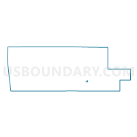
Voting District 1216952000001, Muskegon County, Michigan
About
Outline

Summary
| Unique Area Identifier | 598457 |
| Name | Voting District 1216952000001 |
| County | Muskegon County |
| State | Michigan |
| Area (square miles) | 0.41 |
| Land Area (square miles) | 0.41 |
| Water Area (square miles) | 0.00 |
| % of Land Area | 100.00 |
| % of Water Area | 0.00 |
| Latitude of the Internal Point | 43.19546900 |
| Longtitude of the Internal Point | -86.26936560 |
Maps

Graphs
Select a template below for downloading or customizing gragh for Voting District 1216952000001, Muskegon County, Michigan


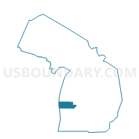
Neighbors
Neighoring Voting District (by Name) Neighboring Voting District on the Map
- Voting District 1215914000001, Muskegon County, MI
- Voting District 1215914000002, Muskegon County, MI
- Voting District 1216952000002, Muskegon County, MI